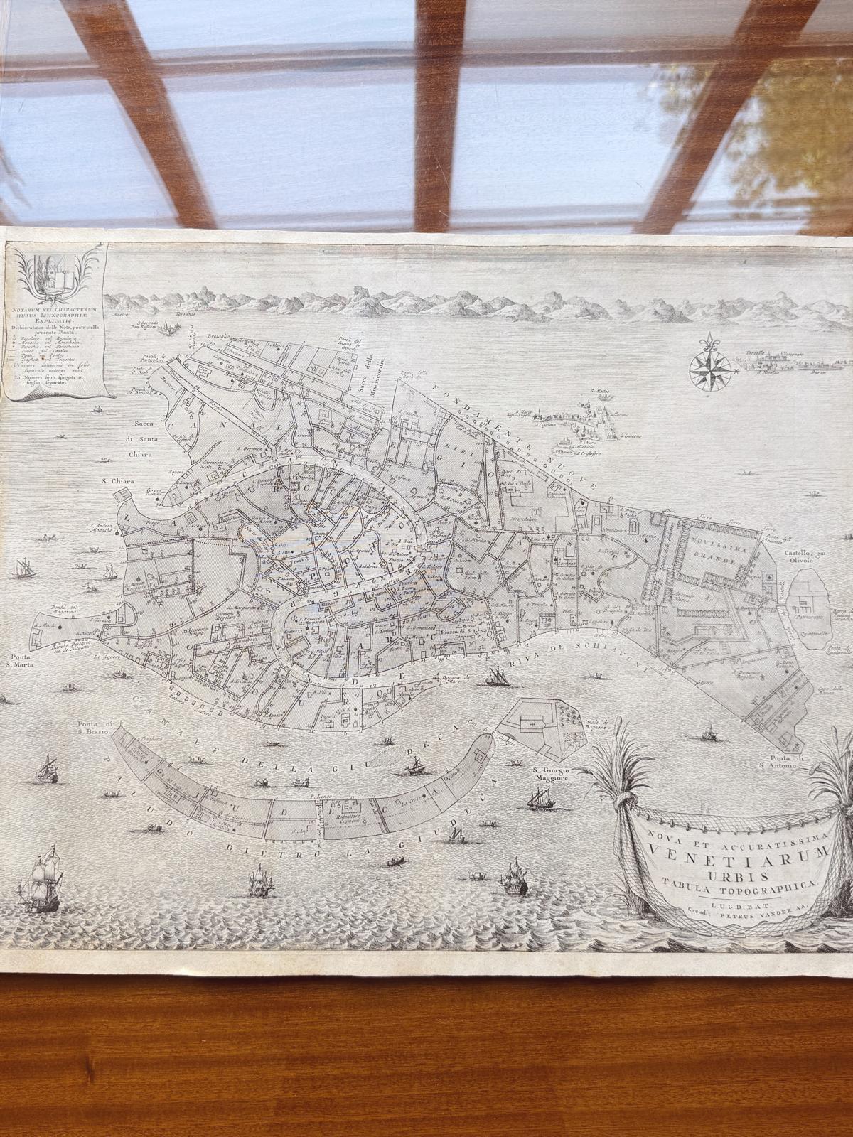
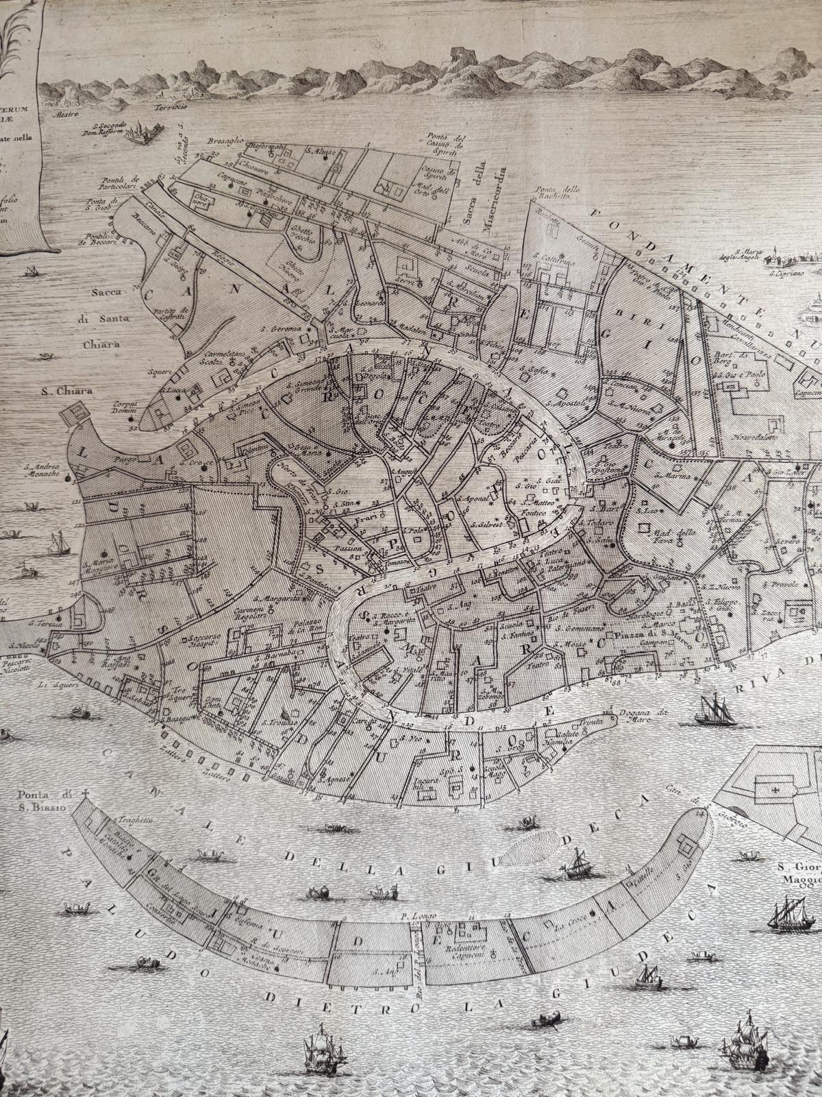


1722 Antique Map of Venice by Petrus van der Aa

A spectacular Antique Map of Venice, Titled “Nova et accussima Venetiarum urbis Tabula topographica”, published by Petrus van der Aa in 1722 in the Thesaurus antiquitatum et historiarum Italiae by Johan Georg Graevius.
Venice is shown as a plan of the Islands, breaking with the traditional bird's-eye view that had prevailed throughout the seventeenth century. This view gives us a functional understanding of Venice, which is divided into the six 'sestieri'. Each sestiere - San Marco, Castello, Cannaregio, Santa Croce, Dorsoduro, San Giorgio Maggiore.
The print has reconstructed margins, having been trimmed in the past; the inking is good, with all of the details clearly legible. The watermark is visible when held up to the light.
Shipping Information
For parcel sized, decorative items, The Italian Collector ships Worldwide anywhere in the world in 1-2 weeks. We ship directly from our warehouse in Umbria.
Parcels are considered Small, Medium or Large depending on their weight and volume. The final shipping cost is calculated at checkout. All parcels are securely packaged and fully insured. For larger furniture items, please see below.
PARCEL SIZED DECORATIVE ITEMS World Wide Shipping Costs
|
European Union |
UK & Switzerland |
USA & Rest of World |
|
|
Small |
€20 |
€50 |
€90 |
|
Medium |
€35 |
€75 |
€150 |
|
Large |
€60 |
€125 |
€250 |
FOR Medium & Large FURNITURE ITEMS World Wide Shipping Costs If you place your order online, shipping prices will be calculated at checkout. For furniture, shipping can take 3-8 weeks depending on the destination country. PLEASE NOTE: On placing your order, you will be contacted by us as the quoted shipping price may vary depending on the specifics of your shipping destination.
If you have any questions regarding your order or shipping, please contact us CustomerService@TheItalianCollector.com and Giulia will respond to your email. Our Office Hours are Monday to Friday 10am to 5pm (CEST). We are able to respond to your email during these hours.
CONTACT
For questions regarding placing your order or shipping, please email CustomerService@TheItalianCollector.com and Giulia will respond to your email. Our Office Hours are Monday to Friday 10am to 5pm (CEST).We are able to respond to your email during these hours.
Choose options

THE QUEST FOR BEAUTY
THE BOTTEGA

join our
monthly newsletter
Early access for Collectors & Designers
The Bottega
Our small by appointment gallery
in Firenze, Italy.
Details
Contact us
Our Office Hours are Monday to Friday
10am to 5pm (CET)
Details
SHIPPING
We ship Worldwide in 1-2 weeks, directly from our warehouse in Umbria.
Details
HOW TO SPEND IT
"One of the World's Best Antique Shops"
HTSI, The Financial Times